

A research team based at the Technical University of Munich (TUM) has produced what it says is the first high-resolution 3D map of all buildings worldwide.
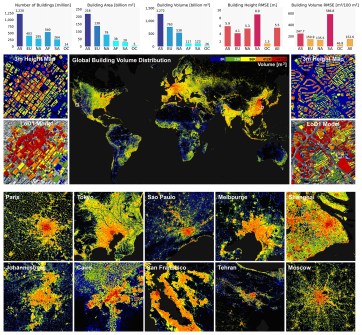
The GlobalBuildingAtlas comprises 2.75 billion building models, encompassing all structures captured in PlanetScope satellite imagery from the year 2019.
That’s 1 billion more buildings than the previous largest global dataset. And GlobalBuildingAtlas vastly improves on the resolution: 3 x 3 metres compared to previous global models’ 90-metre resolution.
According to the researchers, the openly available dataset provides a basis for climate research and the implementation of the UN Sustainable Development Goals by enabling more precise models for urbanisation studies, infrastructure planning and disaster management.
3D map for urban development
The effort was led by Professor Xiaoxiang Zhu, holder of the Chair of Data Science in Earth Observation at TUM.
“3D building information provides a much more accurate picture of urbanisation and poverty than traditional 2D maps,” said Professor Zhu.

“With 3D models, we see not only the footprint but also the volume of each building, enabling far more precise insights into living conditions.
“We introduce a new global indicator: building volume per capita, the total building mass relative to population — a measure of housing and infrastructure that reveals social and economic disparities,” she added.
“This indicator supports sustainable urban development and helps cities become more inclusive and resilient.”
3D map data detail
The researchers say that GlobalBuildingAtlas provides comprehensive building polygons, heights and level of detail 1 (LoD1) 3D building models based upon:
- GBA.Polygon, being the set of global building polygons for 2.75 billion buildings;
- GBA.Height, claimed to be the most detailed and accurate global 3D building height map to date, with spatial resolution of 3 x 3 m and root mean square errors (RMSEs) ranging from 38.0 to 580.0 cubic metres per 100 square metres across different continents; and
- GBA.LoD1, which the authors claim is the first complete global LoD1 building model, including 2.68 billion building instances with predicted heights, with RMSEs ranging from 1.5 to 8.9 metres across different continents.
Essentially, those 2.68 billion buildings are provided simplified 3D representations that capture the basic shape and height of each structure.
Although not as detailed as those provided by higher LoD levels, the data can be integrated at scale into computational models, forming a basis for analyses of urban structures, volume calculations and infrastructure planning.
The researchers say that, unlike previous datasets, GlobalBuildingAtlas includes buildings from regions often overlooked in global maps, such as Africa, South America and rural areas.
The paper is available online: Zhu, X. X., Chen, S., Zhang, F., Shi, Y., and Wang, Y.: GlobalBuildingAtlas: an open global and complete dataset of building polygons, heights and LoD1 3D models, Earth Syst. Sci. Data, 17, 6647–6668, https://essd.copernicus.org/articles/17/6647/2025/.


