MapInfo Stratus is a web-based mapping application that provides current information about the location of assets, businesses and services. It provides an efficient way to publish information-rich maps to your website for easy user access and interaction – with no GIS experience required.
MapInfo Stratus provides 24/7 access to location-based data and analysis via the cloud – ideal for disseminating public information, enabling business users to fulfill mapping requests, and sharing geo-based enterprise data with co-workers, citizens, constituents and customers.
From marketing planning, to sales territories, to citizen information, to business performance and projections, Stratus enables users to quickly access and view the information they need.

MapInfo Stratus for Government:
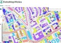
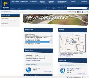
MapInfo Stratus is ideal for publishing maps and disseminating information to make it easy for citizens to find out more about government assets and services such as the location of schools, parks, libraries and public transport. Traditionally Councils have relied on multiple channels to answer citizen questions leaving customers confused about where to source the right information and unsure of the information they receive.
MapInfo Stratus for Business:
Information drives well-informed decision making—whether you’re evaluating market opportunities, assessing the competition or looking at expansion. In many organisations, GIS analysts spend hours creating maps for individuals who need access to this visualisation but may not have the mapping software or expertise to pull this information directly. Now, with MapInfo Stratus, management can quickly and easily retrieve the information they need, according to their own business parameters, without GIS analyst involvement.
For further information please visit: www.mapinfostratus.com.au.
Pitney Bowes Software. Email: pbsoftware.australia@pb.com or Ph: 02 9437 6255.