

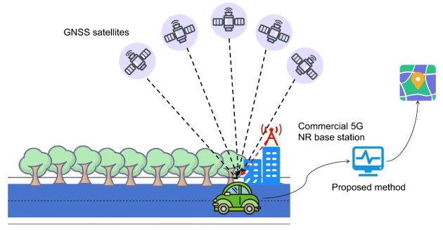
A new study presents an approach that combines commercial 5G New Radio (NR) signals with GNSS to overcome the limitations of satellite-based navigation in urban canyons.
By strengthening 5G signal tracking and deeply fusing it with satellite measurements, the method significantly improves both ranging stability and positioning accuracy.
Real-world tests show that the system maintains reliable performance even in heavily obstructed environments and when only a few satellites are available, offering a promising solution for robust urban navigation.
The study has been published (DOI: 10.1186/s43020-025-00183-8) in Satellite Navigation by researchers from Wuhan University, The Chinese University of Hong Kong (Shenzhen), and Shandong University of Science and Technology.
The research introduces a deep fusion strategy that enhances both signal tracking and positioning estimation.
At the signal level, the team developed a method that jointly uses 5G synchronisation and reference signals to stabilise tracking in environments affected by multipath interference. This design substantially reduces ranging errors compared with conventional 5G-only approaches.
To further improve performance under weak signal conditions, a phase-stabilised Kalman filter was incorporated into the tracking loop, helping maintain accurate carrier phase estimates even when signal quality drops.
Beyond signal processing, the study applies an extended Kalman filter to deeply fuse 5G and GNSS measurements. Unlike loosely and tightly coupled methods, the fused position and clock estimates are fed back to correct the 5G tracking process in real time.
Field experiments conducted in complex outdoor environments show that this deep integration significantly improves positioning accuracy in both horizontal and vertical directions.
Importantly, the system continues to deliver reliable positioning when satellite visibility is severely limited.
“This work shows that commercial 5G signals can do much more than support communication,” an author of the study said.
“By deeply integrating 5G with GNSS and addressing real-world challenges such as multipath and clock errors, we demonstrate a practical pathway toward reliable urban positioning.
“The key advantage is robustness — our system continues to work when satellite-only solutions struggle. This opens new possibilities for navigation in cities, where reliable positioning is often the hardest to achieve.”


