


Digital Twin | BIM World Paris is a leading event dedicated to digital technology and innovation for buildings, infrastructure and territories. New reorganised, it is to be structured around the pillars of: Smart and safe territories and cities where technologies help improve the living environment, and connected buildings, through the digitalisation of processes, construction tech, AI, BIM, digital twins.
The major themes will be:
- BIM, GIS and interoperability
- Design, construction, building and renovation
- Decarbonisation, energy and sustainable development
- Infrastructure and cities
- Skills and training
- Data, AI and cybersecurity
- Digital twins

Join experts from artificial intelligence (AI) and data science, thematic applications, engineers and research scientists active in the field of foundation models (FMs) applied to climate, weather, Earth observation (EO), and Earth sciences from across the globe in this workshop hosted by NASA and ESA (European Space Agency).
The Second ESA-NASA International Workshop on AI Foundation Model for Earth Observation will focus on further strengthening cross-agency and cross-disciplinary collaboration between the EO and AI/FM communities to advance the transition of foundation models from research prototypes to operational, trustworthy, and impactful Earth science tools.
The key goal of the workshop is to foster meaningful exchange across science, applications, and operations, while creating space for emerging topics such as agentic AI, novel applications, benchmarking frameworks, and responsible AI use.
Image courtesy NASA
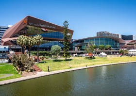
South Australia’s Spatial Information Day (SID) will be held on Friday, 7 August at the Adelaide Convention Centre.
An annual highlight of the South Australian geospatial community’s calendar, SID brings together experts from the fields of surveying, GIS, remote sensing, photogrammetry and more, for wide-ranging discussions and networking.
The theme for 2026 is ‘Every future starts somewhere: From ground truth to space, shaping what comes next,’ and for 2026 the organisers are hoping to attract around 400 delegates and 40 speakers. This year will also see the introduction of the inaugural South Australian EISSI Awards Dinner.
The call for abstracts and papers is now open, with speakers invited to submit their ideas within a wide span of topics, such as:
- Various spatial disciplines, e.g. GIS, surveying and so on;
- Real-world case studies;
- Insights into innovation techniques and approaches;
- Smart cities and infrastructure;
- Emerging technologies.
A sponsorship prospectus is now available, while tickets for the event are expected to go on sale soon.
With a theme of ‘Strengthening and Expanding Geospatial Networks in the Pacific Islands,’ the 2026 Pacific Islands GIS & RS User Conference aims to build and enhance geospatial networks in the Pacific Islands by being a forum where experts, practitioners and policymakers can explore cutting-edge geospatial technologies and collaborations.
The conference is the largest GIS and remote sensing conference attended by Pacific Islanders, attracting more than 300 attendees every year. The event will offer a unique platform to share knowledge, strengthen regional partnerships, and drive innovation in mapping, remote sensing and spatial data infrastructure.