


Registration is open for the 2026 GEO Symposium and GEO-21 Plenary, which will take place from 26 to 28 May 2026 in Geneva, Switzerland.
Held under the theme of ‘Investing in Earth Intelligence for a Resilient Future,’ the event will convene governments, space agencies, research organisations, private sector innovators, and development partners to explore how Earth intelligence (EI) can drive transformative, resilient solutions for people and the planet at a pivotal moment in the implementation of GEO’s Post-2025 Strategy.
The sessions will highlight user-driven solutions, open data and open knowledge practices, co-designed products and services, emerging partnerships, and investment opportunities that advance EI and GEO priorities.
The event will be livestreamed, for which registration is not required.

The Tasmanian State of GIS Conference 2026 will be held in Hobart on 3 June.
The Conference will bring together Tasmania’s geospatial community of practitioners, researchers, technologists and decision-makers to share ideas, showcase innovations, and chart the future of spatial thinking.
The theme for this year’s conference is ‘Island to Insight: AI, Analytics and the Digital Landscape,’ reflecting the ongoing convergence of the geospatial sector and the IT world.
Tasmanian geospatial endeavours cover a wide range of activities in sectors such as precision agriculture, forestry management, coastal monitoring, polar science and major infrastructure delivery.
Presentations will cover current and future advanced analytics and AI workflows and how they challenge, compliment or enhance traditional GIS and Earth observation practices.
Image credit: ©iStock.com/FrankRamspott
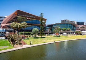
South Australia’s Spatial Information Day (SID) will be held on Friday, 7 August at the Adelaide Convention Centre.
An annual highlight of the South Australian geospatial community’s calendar, SID brings together experts from the fields of surveying, GIS, remote sensing, photogrammetry and more, for wide-ranging discussions and networking.
The theme for 2026 is ‘Every future starts somewhere: From ground truth to space, shaping what comes next,’ and for 2026 the organisers are hoping to attract around 400 delegates and 40 speakers. This year will also see the introduction of the inaugural South Australian EISSI Awards Dinner.
The call for abstracts and papers is now open, with speakers invited to submit their ideas within a wide span of topics, such as:
- Various spatial disciplines, e.g. GIS, surveying and so on;
- Real-world case studies;
- Insights into innovation techniques and approaches;
- Smart cities and infrastructure;
- Emerging technologies.
A sponsorship prospectus is now available, while tickets for the event are expected to go on sale soon.

The Survey and Spatial New Zealand Conference 2026 aims to connect the surveying and spatial community to explore innovation, technology and the future of the profession.
The event will attract professionals from across land development, urban design, resource management, civil engineering, surveying (cadastral, hydrographic and engineering), positioning and measurement, and spatial/GIS for two days of insights.
Registrations are due to open in April 2026.
Image credit: ©stock.adobe.com/au/StudioProX
With a theme of ‘Strengthening and Expanding Geospatial Networks in the Pacific Islands,’ the 2026 Pacific Islands GIS & RS User Conference aims to build and enhance geospatial networks in the Pacific Islands by being a forum where experts, practitioners and policymakers can explore cutting-edge geospatial technologies and collaborations.
The conference is the largest GIS and remote sensing conference attended by Pacific Islanders, attracting more than 300 attendees every year. The event will offer a unique platform to share knowledge, strengthen regional partnerships, and drive innovation in mapping, remote sensing and spatial data infrastructure.