


The Association for Geographic Information’s (AGI) Foresight Conference 2025 will be held in London on 13 November, at which will be launched the The Foresight Report 2030, the result of a 12-month project exploring the opportunities and challenges facing the geospatial sector over the next five years.
The conference agenda features an keynote presentation from Ed Parsons, Geospatial Technology Advisor and Google’s first ever Geospatial Technologist, who will be joined by representatives from Amentum, AtkinsRéalis, Idox Geospatial, 1Spatial and the North Sea Transition Authority.
The innovative geospatial sector program also features opportunities to explore the themes of the Report — the Data Imperative, the AI Integration Challenge, Infrastructure Evolution, the Collaboration Imperative, Earth Systems Revolution, Skills Revolution, and the Convergence Effect.
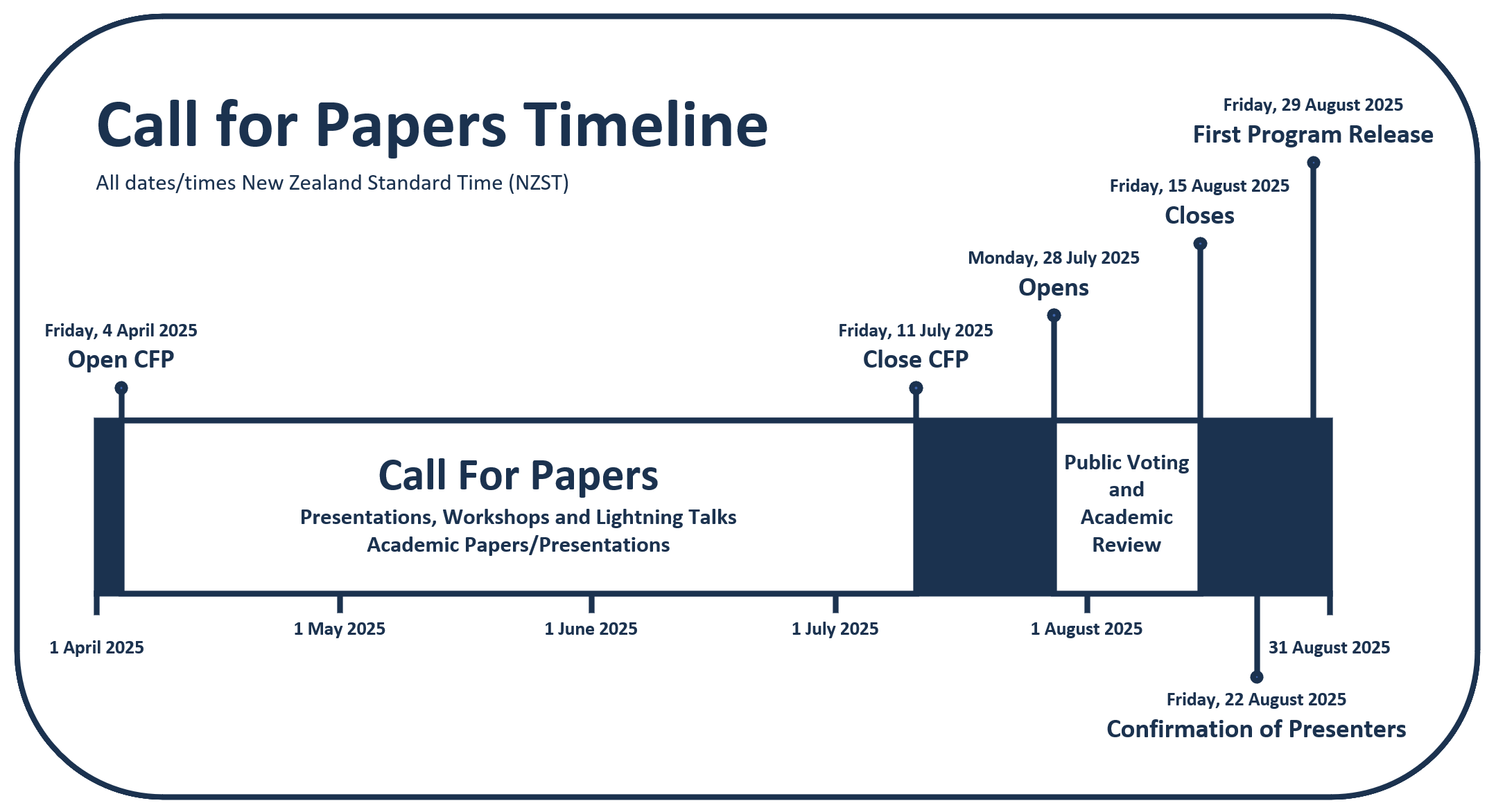
The Free and Open Source Software for Geospatial (FOSS4G) conference series, hosted in partnership with OSGeo, brings together open source geospatial users, software developers, decision makers and researchers from around the world.
The FOSS4G 2025 conference in Auckland, New Zealand, will be a vibrant gathering that fosters collaboration and celebrates innovation in the exciting world of free and open source software for geospatial.
The event will feature workshops, technical sessions, keynote addresses, ‘lightning talks,’ code sprints and community events, social events and a ‘women in geospatial’ breakfast.
It is expected that the full program will be made available in August 2025.

C.R. Kennedy and Leica Geosystems will showcase the Leica TS20 robotic total station at a series of launch events around Australia.
According to Leica Geosystems, the TS20 features upgraded hardware, software, and connectivity for a faster, quieter and more reliable experience in the field. From wireless communication and field and office software to theft deterrence and data sync, it’s fully connected and secured.
The 2025 Pacific GIS & Remote Sensing User Conference will be held in Suva, Fiji, from 24 to 29 November.
This is the largest annual GIS and remote sensing event held within the Pacific Island community, regularly bringing together more than 300 experts from government, academia and industry for five days of presentations and workshops.
The event will also include nightly social functions that will enable participants to relax and network in informal settings.
The conference is organised by the Pacific GIS and Remote Sensing Council.
C.R. Kennedy and Leica Geosystems will showcase the Leica TS20 robotic total station at a series of launch events around Australia.
According to Leica Geosystems, the TS20 features upgraded hardware, software, and connectivity for a faster, quieter and more reliable experience in the field. From wireless communication and field and office software to theft deterrence and data sync, it’s fully connected and secured.

The international PNT 2026 conference will be held at Royal Randwick racecourse in Sydney from 4 to 6 February, 2026. The premier Australasian event dedicated to positioning, navigation and timing (PNT) technologies and research, it is being led by the newly established PNT Sub-Committee of the Australian Institute of Navigation (AIN).
Building on the legacy of the IGNSS conference series, the conference is expected to attract many hundreds of PNT experts from around the world, who will gather to learn about research, policy and applications spanning GNSS, autonomy, resilience, and the next generation of multi-GNSS infrastructure.
Keynote speakers included Lieutenant General Susan Coyle, Chief of Joint Capabilities within the Australian Defence Force, and Professor Zak Kassas, the TRC Endowed Chair in Intelligent Transportation Systems at The Ohio State University.
Early bird registration rates are available until 30 November 2025, with significant discounts on offer. Registration includes:
- Access to all sessions and the exhibition
- Morning and afternoon teas and lunches
- Networking drinks with exhibitors
- The PNT 2026 harbour cruise dinner
- Delegate materials and app access
The event also will include a large exhibition area, for which a limited number of sponsorship and exhibition packages are available.
The BYDA Utility Safety Conference will take place from 4 to 5 March, 2026 at the RACV Club, Melbourne. This conference is where Australia’s utility, construction and geospatial sectors come together to share knowledge, challenge old ways of working, and explore new ideas that make the industry safer and smarter.
On show will be BYDA’s Digital Utility Portal, which is moving from proof-of-concept into the next phase of development. The portal is showing how digital data sharing can dramatically reduce manual rework, improve accuracy, and give planners and engineers the real-time insight they need to prevent strikes.

The Association of Public Authority Surveyors (APAS) 2026 Conference will be held in the quaint but bustling Southern Tablelands town of Bowral.
The theme of the conference is ‘Now that’s a boundary!’, which references the fact that Bowral is where the famous cricketer Sir Donald Bradman grew up and also that it is home to the Bradman Museum & International Cricket Hall of Fame.
For those who have had abstracts accepted, the next deadlines are: Draft paper deadline: Friday, 14 November 2025; final paper deadline: Friday, 16 January 2026.
APAS is a non-profit organisation that brings together surveyors and closely allied spatial information professionals employed by public authorities in both New South Wales and the Australian Capital Territory.

Geo Connect Asia is the annual regional meeting place to bring practical and proven solutions to the market, combining four overlapping exhibitions with a series of conferences to exchange inspiring ideas and share cross-industry experiences. It is an exclusively in-person, trade show-driven event, with strong live content that engages both a Singapore-based and a regional audience.
More than 3000 delegates are expected to attend the 2026 event, with more than 35% of those coming from the wider APAC region and beyond.
The 2026 Main Conference theme, Transforming technology into solutions: underground, land and sea to sky, will seek to match practitioners from the user community with policymakers and the broader community to deliver outcomes to advance the value of the industry.
Delegate registration will open on 28 October 2025.
Geospatial World Forum (GWF) is a collaborative and interactive event that demonstrates the collective and shared vision of the global geospatial community.
This annual gathering brings together geospatial professionals and leaders representing national mapping agencies, private sector enterprises, multilateral and development organisations, scientific and academic institutions, and large end-users from government agencies and private businesses.
Geospatial World Forum 2026’s theme will be Sovereignty, Economy & Society, and the event is expected to attract:
- 50-plus partners
- 75-plus exhibitors
- 2,000-plus attendees from 100-plus countries
- 500-plus speakers
- Representatives from 1,000-plus organisations
For 2026, GWF returns to the location of its first iteration, the RAI Congress Centre in Amsterdam.