

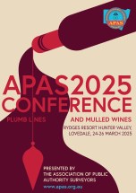
The Association of Public Authority Surveyors (APAS) 2025 Conference will be held at the Rydges Resort Hunter Valley, Lovedale, NSW, in March 2025. The theme of the event will be ‘Plumb lines and mulled wines’.
The current program (continually updated) can be found here, and includes a gala dinner.
APAS is a non-profit organisation that brings together surveyors and closely allied spatial information professionals employed by public authorities in NSW and the Australian Capital Territory.

Now in its second decade, the Aus Gov Data Summit is dedicated to advancing the government’s agenda of leveraging data as a national strategic asset. This premier event aims to empower Australian public service data leaders to elevate their missions, increase efficiency, and deliver exceptional public services.
With more than 500 leaders from federal state, and local governments expected to attend, the summit will feature an expanded program with four dedicated streams: C-suite, data and analytics, ICT leadership and innovation, and cybersecurity. Each stream is specifically tailored to address the critical challenges and opportunities within the Australian public service data ecosystem.
Image credit: ©stock.adobe.com/au/r-o-x-o-r

The Centre for Spatial Data Infrastructures and Land Administration (CSDILA) at the University of Melbourne, will host the Global Geospatial and Land Community at Melbourne Connect.
The program will include a Certified Leadership Training Course, which will equip executives and leaders with the knowledge, skills and insights needed to leverage geospatial technologies effectively, drive innovation within their organisations, and respond proactively to the evolving landscape of geospatial challenges and opportunities.
The associated Global Forum on Advancing Land and Geospatial Knowledge and Innovation will see the CSDILA and UN-GGIM bring together a leading team to deliver specialised leadership training in the domains of geospatial data and land administration.
Image credit: ©stock.adobe.com/au/Artofinnovation
GISTAM 2025, the 11th International Conference on Geographical Information Systems Theory, Applications and Management will be a meeting point of researchers and practitioners that address new challenges in geospatial data sensing, observation, representation, processing, visualisation, sharing and management.
This includes all aspects of information communication and technologies as well as management information systems and knowledge-based systems.
The conference will present original contributions of either practical or theoretical nature, including research and applications of specialised or interdisciplinary natures, addressing different aspects of geographic information systems and technologies.
Topics to be covered include:
- Data acquisition and processing
- Remote sensing
- Interaction with spatial-temporal information
- Spatial data mining
- Managing spatial data
- Modelling, representation and visualisation
- GIS and climate change
- Domain applications
Deadlines:
- Regular Paper Submission: 13 December 2024
- Abstracts Track Submission: 30 January 2025
Planning is underway for the Country Surveyors Association 2025 Easter conference. Registration will open early in 2025.
The International Federation of Surveyors (FIG) Working Week 2025 will be held at the Brisbane Convention & Exhibition Centre from Sunday, 6 to 10 April 2025.
The theme for the event will be: Collaboration, Innovation and Resilience: Championing a Digital Generation.
The Convenor for FIG Working Week 2025 is Steve Jacoby, Executive Director, Spatial Information at Department of Resources (Queensland) who has 23 years’ experience as a Senior Executive with the Queensland and Victorian Governments, leading their Spatial Information businesses. Steve has a keen interest in information management and seeing the use of spatial information reach its potential within government, business and the public.
The Program Chair is surveyor, Peter James who is the Business Development Manager, Cohga an Australian company with a focus on the development of IT products, and the provision of associated professional services. Peter is also the son of Earl James, Australia’s first and only FIG President.
FIG Working Week 2025 is a great opportunity for Australia’s geospatial community to showcase their technical expertise, strong research capability and warm hospitality.
For 2025, the annual Locate conference will be held in conjunction with the FIG Working Week 2025 conference, with both taking place alongside each other at the Brisbane Convention & Exhibition Centre, from 6 to 10 April.
Locate25 and FIG Working Week 2025 will offer unparalleled access to the international surveying and geospatial community, providing a platform to exchange experiences and stay at the forefront of developments across various aspects of surveying and geospatial practices, including ethics, standards, and education.
The overall theme for the 2025 event is ‘Collaboration, Innovation and Resilience: Championing a Digital Generation.’ It will feature an insightful and technical program with local and international practitioners, allied professionals and academics speaking on their field of expertise.

The Geo Connect Asia Show and Conference has scaled up from its launch in 2020 to become the regional meeting place for the fast expanding geospatial, positioning, digital construction and remote sensing markets.
With the growing application of geospatial based knowhow in decision-making across government, enterprise and non-profit the annual event comprises a show with a mix of thought leadership and technical platforms.
Last year’s event attracted more than 100 leading companies and 2494 visitors. Its co-location with Drones & Uncrewed Asia both presents the global UAV industries, but also addresses the importance of data acquisition and analytics in critical and emerging vertical markets.
Digital Construction Asia adds particular focus on the development of one of the region’s largest industries.
The addition of Marine & Hydro Asia expands the reach into the region’s hydro-marine data markets, which are so critical to the economy and security of Southeast Asia.
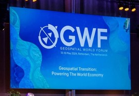
Geospatial World Forum (GWF) is a collaborative and interactive event that demonstrates the collective and shared vision of the global geospatial community.
This annual gathering brings together geospatial professionals and leaders representing national mapping agencies, private sector enterprises, multilateral and development organisations, scientific and academic institutions, and large end-users from government agencies and private businesses.
This, the 16th edition of the Forum, will be held in Madrid, Spain.
The third International Association of Geodesy (IAG) Commission 4 Symposium will bring together scientists, researchers and professionals working in the broad field of positioning and its applications.
The symposium will serve as a platform for discussing research that leverages current and emerging positioning techniques and technologies. It aims to provide both practical and theoretical solutions across a wide range of topics.
Discussions will address both technical and institutional aspects of developing GNSS backup systems, integrated positioning solutions, resilient PNT systems, and emerging LEO-based PNT techniques. The symposium will also explore space weather monitoring and forecasting through both ground-based and space-based geodetic observations. Additionally, the application of machine learning and artificial intelligence in geodesy will be examined.
The main topics to be covered include:
- Multi-frequency and multi-constellation GNSS technique
- Terrestrial and satellite-based positioning system development
- Multi-sensor fusion navigation and integrity monitoring
- Emerging positioning technologies, e.g., resilient PNT and LEO-based PNT
- Atmospheric space weather monitoring using geodetic observation techniques
- Applications of geodesy to engineering
- Artificial Intelligence technique for geodesy research