Astrium Services is to combine its satellite imagery and geo-information businesses Spot Image and Infoterra into one business division.
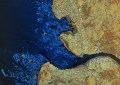
The newly-formed geo-information division will offer a range of products and services including multisource imagery, multi-resolution optical imagery, radar satellite imagery and high value-added solutions.
Astrium Services’ chief executive Eric Béranger said the move was part of a goal to become a world leader in the field of geo-information solutions.
“Astrium Services is focused on our recent commitment to financing the next generation of SPOT satellites, and the current TerraSAR-X and most recent TanDEM-X missions are a clear demonstration of our ambition,” he said.
The division will also invest heavily in research and development to bring new products to market.
Other products offered by the division will include 3D urban simulations, digital elevation models, and a set of market-oriented geospatial services for sectors such as defence and security, agriculture, oil & gas, urban planning, insurance and environment.
The division is currently helping implement a national spatial data infrastructure for Serbia.
Patrick Le Roch has been made the new divisional managing director of the new division.
Astrium is a wholly-owned subsidiary of EADS.