Developed by UNSW researchers, MapAI helps users explore housing and infrastructure data through plain-language questions… and see the evidence behind the answers.
MapAI, an AI-powered mapping platform has officially gone live in public, aiming to help make complex geospatial data easier to analyse and verify.
Developed through three years of research at UNSW’s City Futures Research Centre, the platform allows planners, governments and businesses to ask questions about places in everyday language and see the evidence behind the answers.
For example, users can ask in plain language which schools are in bushfire-prone areas, how much land within 800 metres of a train station is zoned for housing, or where demand for affordable housing is greatest.
MapAI’s generative AI technology produces the code that sits between the query and the data.
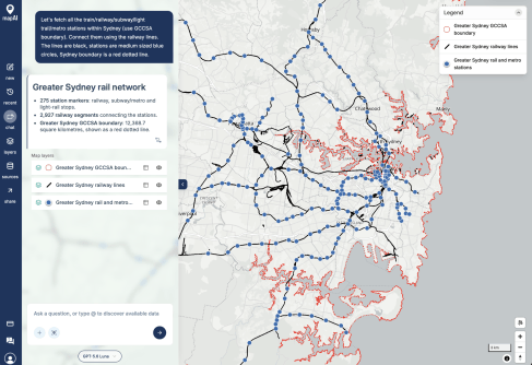
MapAI searches relevant datasets, combines the information and runs spatial analyses. It then generates maps showing the sources, assumptions and steps behind each result.
Users can inspect the evidence and assess whether the findings are suitable for their decisions.
Making spatial analysis faster and easier
Lead researcher, Scientia Professor Chris Pettit, director of UNSW’s City Futures Research Centre, says the technology could help planners assess housing developments, transport networks and infrastructure needs without spending hours gathering information from different sources.
“Decisions, such as assessing whether existing suburban infrastructure can absorb new homes or whether upgrades are needed, often rely on information held across multiple datasets, systems and organisations,” said Professor Pettit.

“Bringing this information together takes significant time and specialist expertise before analysis can begin. MapAI brings together disparate datasets to fast-track the process.”
MapAI draws on publicly available government datasets, including Australian Bureau of Statistics data and NSW property, infrastructure and zoning data. Users can create maps tailored to their needs, refine their questions and review the datasets used in each analysis.
“MapAI enables users to interrogate maps in plain language, integrate their own datasets and clearly see the evidence behind every analysis,” said MapAI’s CEO, Steve Taitoko.
“The platform provides transparency around the data, methods and assumptions used to generate results, while allowing users to customise analyses, save workflows and export geospatial information for planning, reporting and consultation.
“By democratising access to geospatial data, MapAI empowers more people to contribute to the development of liveable and sustainable cities.”
Like having a spatial analyst in your back pocket
The platform builds on three years of research at UNSW’s City Futures Research Centre into how AI can make spatial analysis more reliable and transparent.
MapAI combines generative AI with GIS, allowing users to analyse geospatial data alongside their existing mapping tools.
“With MapAI, you can talk to the map, you can drag and drop your own data, and you can see which datasets were used in your analyses at a glance,” said Professor Pettit.
The technology works alongside existing mapping software and the specialists who use it, rather than replacing them.
“MapAI sits alongside your existing GIS, whether that’s ArcGIS, QGIS, a spatial database or your organisation’s own data,” says MapAI’s CTO, Balamurugan Soundararaj.
It handles the repetitive tasks, such as finding, checking, reconciling and combining data, and creates a transparent evidence trail.
“What MapAI doesn’t do is replace your GIS, or the specialists who run it. Interpretation, uncertainty and accountability stay with the professional. MapAI makes the evidence faster to assemble and easier to check,” he says.
“MapAI is like having a spatial analyst in your back pocket, backed by your GIS team’s expertise and methods,” added Professor Pettit.
Mapping community experiences of disaster recovery
MapAI’s technology is also being used to help people explore first-hand accounts of disaster recovery from around the world.
The map HowWeSurvive, for instance, brings together more than 1,300 first-hand accounts of disaster recovery, highlighting the experiences of communities often overlooked in disaster planning.
A user, such as the NSW Reconstruction Authority, can filter stories according to location, disaster type, year and stage of recovery. They can also explore themes and locations of interest on the map and identify common experiences and challenges across communities.
The platform helps policymakers and disaster response organisations better understand people’s experiences and consider them when planning future responses.
Individuals can start using the MapAI Explore platform for free with a monthly credit allowance, while organisations can request structured trials.
Related reading: