A new book by an Australian academic traces the history of ocean mapping and uncovers the effects it has had on science, policy and environmental protection.
Plotting the Oceans: Stories of Powerful Maps and Their Makers, authored by University of Wollongong (UOW) Associate Professor Sarah Hamylton, has been published by Monash University Publishing.
The book explains how ocean mapping has influenced our understanding of our planet throughout history, and how it remains relevant for informing, understanding and responding to concerns such as climate change.
“To sit in a map library and examine collections of maps that have been archived over the ages tells us more about ourselves than the landscapes of the past,” said Hamylton, President of the Australian Coral Reef Society and Director of UOW’s Spatial Analysis Laboratory.
Driving science
“We can trace our changing relationship with the world through the eyes of mapmakers working with their own interests and biases,” said Hamylton.
“Maps are often treated as neutral tools but they are deeply human creations. They reflect the questions we ask, the values we hold, and the futures we imagine.”
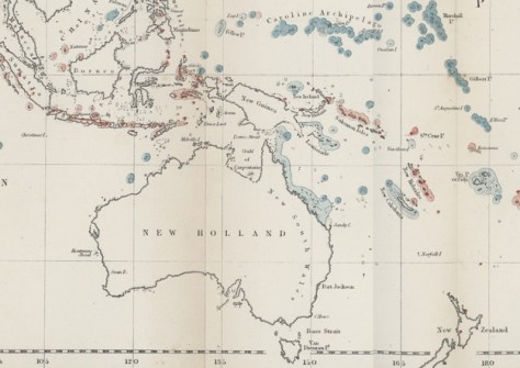
Hamylton uses five case studies to show how ocean exploration and mapping has helped drive scientific revolutions — from Charles Darwin’s coral reef charts to Marie Tharp’s mapping of the ocean floor.
She also shows how it has been used to protect endangered species and light the fire under geopolitical claims, particularly in the modern age of satellite remote sensing and seabed mapping.
The power of maps
Hamylton has spent more than 20 years mapping coastal and marine environments across Australia and the Indo-Pacific, as well as the Indian Ocean and Red Sea.
Her work has helped establish marine protected areas and influenced coastal management policy. She has also published more than 100 scientific papers and several other books on coastlines and mapping.
She’s also part of the team that was recently awarded a $650,000 ARC grant to purchase equipment for drone-based LiDAR mapping of Australian coastal environments.
“As a coastal mapmaker, my job might involve sailing, scuba diving, making digital maps from drone images or developing spatial models. It’s a magical combination of activities that never gets boring,” she said.
“Understanding the power wielded by maps brings an opportunity to think carefully about what I produce, and how it will be used. This enhances rather than diminishes my craft.”