

Researchers have combined geospatial flood mapping, socioeconomic data and property market information to see how different regions fare in the face of extreme weather events.
The team, led by Dr Antonia Settle from Monash University, looked at whether those from lower-socioeconomic groups are more exposed to flood risk and suffer worse impacts when floods occur, than those from higher socioeconomic groups.
The study found that households already experiencing disadvantage are frequently those that are most exposed to climate risks and have fewer financial reserves to call upon when disaster strikes.
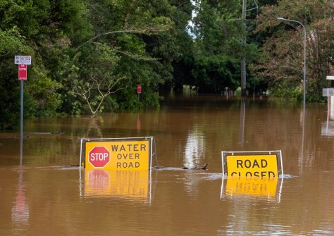
Using data from the 2022 floods in the flood-prone Northern Rivers region of New South Wales, the team compared the experiences of wealthy coastal communities and less wealthy inland towns.
Looking at house prices before and after the floods and combining that with socioeconomic demographic data, it found that areas already known to be prone to flooding were characterised by lower incomes, higher unemployment, more single-income households and cheaper housing.
The 2022 floods only made the inequalities worse.
Perhaps unsurprisingly, in poorer inland towns, house prices plunged by 27% after the floods and the number of properties on the market rose sharply, pointing to distressed sales.
The worst time came 18 months after the floods, when some households were no longer able to hold on in the face of the economic disruption the disaster brought.
“The strength of this analysis came from being able to integrate geospatial flood mapping with detailed property-level data through AURIN,” said Dr Settle.
“That combination allowed us to examine climate impacts at a level of granularity that is rarely possible in Australia.”
The study has provided a clear demonstration and empirical evidence that climate-related disasters affect Australian households unequally by amplifying existing inequalities.
The study was made possible through the ability of AURIN’s Data Portal to bring together the necessary demographic, flood-risk and property-level data.
“Making high-quality property and housing data available through AURIN is essential for understanding how climate change is reshaping Australian communities,” said Pascal Perez, Director of AURIN.
“Access to datasets from partners like Australian Property Monitor and Domain ensures researchers can analyse these impacts with confidence and precision.”
The research has been published online in Ecological Economics.


