Spatial software developer, Esri, has released a new mobile app that offers a new way to measure, monitor and communicate changes to ocean environments. The Ecological Marine Units (EMU) app is now available for free for mobile devices and provides a valuable resource for scientists, educators, governments, and industries seeking easily accessible information and imagery about the ocean’s long-term physical and nutrient properties.
The primary data source for the EMU mobile app is the National Oceanic and Atmospheric Administration’s (NOAA) authoritative World Ocean Atlas, a 3D modelled 50-year average temperature, salinity, dissolved oxygen, nitrate, silicate, phosphate model for the entire ocean. It also includes marine chemistry information from the National Aeronautics and Space Administration (NASA) and topographic data from GRID-Arendal.
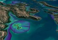
Esri, USGS, and a distinguished group of ocean scientist have taken this data and created Ecological Marine Units, a distinct and statistically categorized collection of 37 ecologically significant ocean water types. The EMU app puts data from 52 million locations throughout the world’s oceans at any user’s fingertips.

The data provided by the app informs how livable marine environments are for ocean-dwelling species as well as the overall health of the ecosystem. For example, organisations involved in fishery planning can use the EMU mobile app to review proposed boundaries with a better understanding of which habitats will likely harbor certain species and manage fisheries more cost-effectively. By using the EMU mobile app, industries that depend on fishing yields can spend less time and money in locations that are less profitable or more sensitive.
On the other side of the coin, conservation groups that need easy access to information on the environments of marine protected areas (MPA) in order to more effectively regulate them now also have a mobile tool for understanding the chemical makeup of these areas.
“The EMU mobile app will serve as a fresh, widely available resource for professionals who benefit from a deeper understanding of the ocean’s structure—its salinity, temperature, oxygen levels, and nutrients,” said Dr. Dawn Wright, Esri chief scientist. “Scientists and nonscientists alike who must study and understand the ocean now have the freedom of a convenient mobile interface with this vast wealth of environmental data.”
The EMU mobile app is free from the App Store and Google Play.