Each month, Spatial Source looks back on the best of the month’s Best of the Blogs.

Mars is open for exploration! NASA is seeking help from spatially capable minds to find the best place to set up an exploration zone (EZ) on Mars. Click here’s to see NASA’s plans and Planet Carto’s long list of possible EZ’s, based on the possibility of water and signs of life.

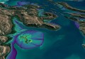
Given a physical 3D elevation model of the world, how can you dramatically show the effects of sea level rise? Simple… just add water! That’s what the artists behind Terra Forming did, with a number of materials, scales and map projections, which as Fast Company describe, has a very moving effect.

The internet’s fascination with remote sensing ballooned to new heights this month thanks to a 15-year-old Canadian. When William Gadoury claimed to have discovered an ancient Mayan city in Mexico by studying star maps and satellite imagery, internet fame quickly ensued. However, since then the archaeological community have spoken out to the likes of VICE and National Geographic to share their extreme doubts in his findings. The jury is out on whether he has found a Mayan city or a much more recently abandoned crop, but perhaps a visit to the site or just some analysis of historical imagery will soon reveal the truth.

If you’re at all skeptical about how close machine learning is to changing our world, have a look at the Tomnod’s blog post that shows who wins when both humans and machine attempt to map all of Adelaide’s swimming pools– the winner… both, sort of.

Last week was a momentum occasion as the first ‘brain-drone race’ was held, as shown by Quartz. Yes, not only can you control a drone using your brain, but you can even race them (and presumably battle them too).