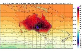
What a Summer, eh? The world is definitely getting hotter, and, as such, the Bureau of Meteorology has had to redesign their temperature map, so as to include a higher maximum possible temperature, as you can see in this now iconic image.
Wired have an interesting take on the matter, noticing that, as temperatures move into extremes, we find ourselves not only living in cities never designed for such temperatures, but also using gadgets that are working outside of their design specs. For instance, according to Apple, the iPhone cannot be safely used above 35ºC, and cannot be safely stored above 45ºC.
Wired have an interesting take on the matter, noticing that, as temperatures move into extremes, we find ourselves not only living in cities never designed for such temperatures, but also using gadgets that are working outside of their design specs. For instance, according to Apple, the iPhone cannot be safely used above 35ºC, and cannot be safely stored above 45ºC.
A trivial consequence of climate change, I know, but it served as yet another example of just how far-reaching the consequences of burning carbon really are.
Google Maps Mania has a post aimed at us southerners (that is, Australian and New Zealanders), which gives some map-based methods to find accommodation or recreation in a given area.
Brisbanites with a penchant for aircraft should take pleasure in another Google Maps Mania post, this one showing the (almost) real-time location of planes around Queensland’s capital.
In an update to last week’s Best of the Blogs coverage of the New York gun owner’s map, All Points Blog alert us that the original publisher of the map, the Lower Hudson Journal News, has decided to remove it from its website.
In fact, Geosprocket has a good, if a little promotional, analysis of the whole situation, including some good rules for data journalism, that’s well worth a read.
Here’s an interesting map, shown on Gary’s Bloggage, that is created by showing the last few months’ worth of Foursquare check-ins.
In honour of the tragic death of Aaron Swartz, O’Reilly media have released its Open Government ebook for free. To quote Tim O’Reilly:
“Open Government was published in 2010 by O’Reilly Media. The United States had just elected a president in 2008, who, on his first day in office, issued an executive order committing his administration to “an unprecedented level of openness in government.” The contributors of Open Government had long fought for transparency and openness in government, as well as access to public information. Aaron Swartz was one of these contributors (Chapter 25: When is Transparency Useful?). Aaron was a hacker, an activist, a builder, and a respected member of the technology community. O’Reilly Media is making Open Government free to all to access in honor of Aaron.”
“Open Government was published in 2010 by O’Reilly Media. The United States had just elected a president in 2008, who, on his first day in office, issued an executive order committing his administration to “an unprecedented level of openness in government.” The contributors of Open Government had long fought for transparency and openness in government, as well as access to public information. Aaron Swartz was one of these contributors (Chapter 25: When is Transparency Useful?). Aaron was a hacker, an activist, a builder, and a respected member of the technology community. O’Reilly Media is making Open Government free to all to access in honor of Aaron.”
Finally, GIS Lounge has a post on some cute little GPS shoes, which serve as silent, stylish, quirky personal navigation devices. And they look good, to boot (HAH! Boot!).