If you want to fly a UAV for either consumer or professional purposes, the first question you should ask yourself is ‘Can I fly here?’
However, with varying rules for flying RPAS (or drones) around aerodromes, helicopter landings and military airspace, it has been a difficult question to answer in Australia.

The optimal scenario, but certainly not always the case.
That’s why Australia’s Civil Aviation Safety Authority (CASA) has just released an official smartphone and web app to help make RPAS operations safer.
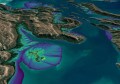
The app, titled ‘Can I fly there?’, displays information about drone safety regulations, as well as maps showing no-fly zones and ‘fly with caution’ zones. It is the first time an official app has been released in Australia to help drone flyers stay safe and abide by the safety regulations.
The app is available on the Google Play store, Apple’s App Store and as a web app for browsers. If using a GNSS-enabled mobile device, ‘Can I fly there’ clearly shows your location against crucial UAV no-fly zones and ‘fly with caution zones.’ The web and mobile apps can also be used for mission planning before heading into the field.
Where can’t I fly?
The data used in the ‘Can I fly there?’ app is sourced from Airservices Australia, the organisation involved in managing all air traffic operations in Australia.
The restricted airspace that is included in the app are the 5.5km restrictions around controlled aerodromes; in approach and departure paths of non-controlled aerodromes; helicopter landing sites; as well as in restricted or military airspace.
The app also highlights ‘caution’ areas around uncontrolled aerodromes and aircraft landing areas, with advice about what to do when flying near these tricky locations. It also uses maps and satellite imagery to further assist mission planning.
Information about airports is also displayed by the app, including satellite photos of runway layouts and whether airports have air traffic control services.

The drone no-fly zones are shaded in red on the map. Orange shading is used to show fly with caution zones around areas where aircraft are known to operate at low altitudes.
CASA’s Group Manager of Aviation, Graeme Crawford, said that the app would also serve to educate Australia’s community on what rules to follow and support safer operations.
“The app will encourage these drone flyers to operate responsibly and to follow our standard operating conditions each and every time they fly,” Crawford said.
“We know people want to have fun with their drones. We want to help them do this safely by reducing the potential for them to fly their drone inadvertently in a way that might cause a threat to aircraft or other people.
“This app will provide them with the relevant content and services they expect to have at their fingertips when out flying.”
Safe skies for all
To develop the app, CASA teamed up with app developers Drone Complier who have created similar services in the United States and South Africa. Like Drone Complier’s namesake app, ‘Can I fly there?’ integrates consumer useability, official air traffic restriction data and satellite remote sensing imagery.
Drone Complier was selected by the Civil Aviation Safety Authority from tender process that opened in September 2016.
The CEO of Drone Complier, Wayne Rochat, said that they were excited to have been selected by CASA to support the Australian sub 2kg drone category.
“Our software is focused on ensuring simple drone compliance, delivering safety and simplicity for both hobbyist and enterprise customers,” Rochat said.
“Drone Complier’s new app will provide CASA with a capability to execute on their vision to create safe skies for all.”
Australia’s federal minister for Infrastructure and Transport said that the app supports valuable innovation in a range of industries, but also that safety is the number one priority.
“Drones are being engaged in industries such as agriculture, mining, infrastructure assessment, search and rescue, fire and policing operations, aerial mapping and scientific research,” he said.
“There is a lot of work being progressed globally on drone safety and security issues, and we are not alone in facing this emerging challenge.”