Users of ContextCaptures photo reality modelling software platfrom will now be able to integrate their datasets with advanced drafting and engineering capabilities.
Bentley Systems have just released ContextCapture Editor, a module that enables users to leverage reality meshes, terrain models, and point clouds made of billions of points and triangles for information modelling workflows.
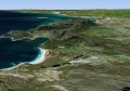
ContextCapture creates accurate 3D models from any digital photographs, including support for the most sophisticated aerial camera systems, including UAVs acquisition systems and laser scanners.
ContextCapture turns simple images into 3D models for even the largest and most challenging 3D models of existing conditions for infrastructure projects of all types, including scales as large as entire cities, without the need for expensive, specialised equipment.
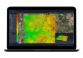
The newly released ContextCapture Editor is a module included with ContextCapture and ContextCapture Center based on Bentley’s PowerDraft CAD software. ContextCapture Editor integrates reality modeling data and engineering data to produce deliverables as i-models, 3D PDF and Ortho Images in any direction.
With the release of ContextCapture Editor, users can now more easily perform the following valuable functions:
- Mesh Retouching
- Generate Cross Sections with Reality Meshes
- Extract Terrain Model from Reality Meshes or Point Clouds
- Breaklines Extraction from Reality Mesh
- Orthophoto Generation on Any Axis
- Real-Time Mesh Classification
- i-model, 3D PDF and Ortho Image Outputs